As a special branch of civil engineering, subsurface utility engineering (SUE) aims to simplify management of risk associated with utility mapping. The SUE process further emphasizes on utility mapping risk management at the most appropriate quality levels. While assessing, designing, and relocating utilities the engineers need to adhere to a set of predefined standard. Earlier, lack of universally accepted standards made it difficult for engineers to implement SUE standards.
The engineers in the United States nowadays adhere to the Standard 38-02 published by the American Society of Civil Engineers (ASCE) in 2003. They refer to the standard entitled “Standard Guideline for the Collection and Depiction of Existing Subsurface Utility Data” to decide the most appropriate way to collect and represent information on subsurface utilities in the United States. The ASCE Standard 38-02 even recognizes and defined four distinct quality levels for assessing the risk associated with using the subsurface utility information for public works projects.
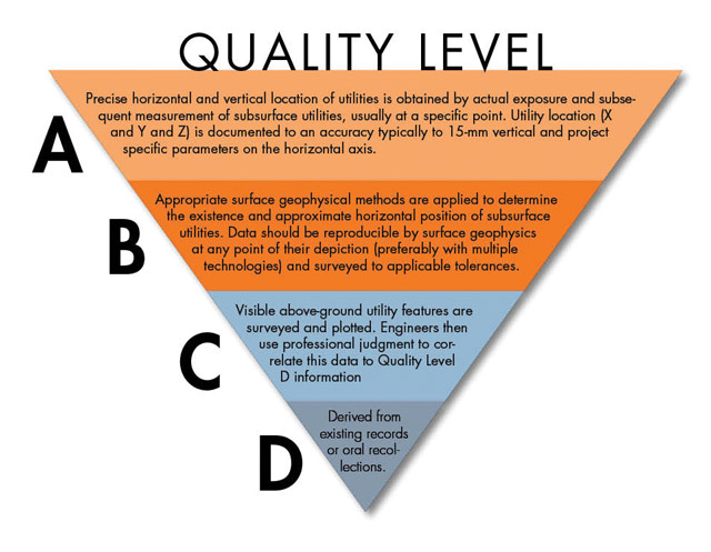
Overview of 4 Quality Levels in Subsurface Utility Engineering (SUE)
- QL-D Data
The specification covers the basic level of utility data which are collected from unreliable sources like personal recollections and existing records. The project owners and engineers cannot use the QL-D data to identify the exact location of specific subsurface utilities. But the data help engineers to assess the overall concentration of various underground utilities. Normally, engineers leverage QL-D data to plan general projects and select various routes.
- QL-C Data
QL-C data is the commonly used standard for utility information assessment. QL-C data covers the data collected by engineers by surveying various visible facilities like valve boxes and manholes. Despite being correlated to QL-D data, the QL-C data identifies the data which are not collected through QL-D sources. Also, the specification aims to identify the utilities that are not plotted accurately. The engineers leverage QL-C data to execute inexpensive projects like relocation and repair of subsurface utilities in various rural areas.
- QL-B Data
The QL-B covers the information required to identify the exact position of subsurface utilities within a specific area. The information is normally collected through the surface geophysical methods. In addition to detecting the exact position of utilities, the information helps engineers to correct the inaccuracies in the utility records and add the missing references. The quality and accuracy of QL-B depend on the geophysical techniques used for selection and classification of utility information. The engineers use QL-B data to accomplish preliminary engineering goals.
- QL-A Data
QL-A data covers the utility information which with optimal accuracy and reliability. The highest level of utility data is collected through a process called locating. The locating process aims to expose the subsurface utilities through a number of nondestructive means by leveraging SUE services fully. The engineers use QL-A data to detect core characteristics – size, type, condition, and composition -of subsurface utilities accurately. Also, the QL-A data help engineers to map the underground utilities optimally in congested urban areas.
Seasoned SUE service providers such as Advanced Infrastructure Mapping, LLC always decide the most appropriate quality level by assessing the quality and reliability of utility information. They even leverage the right SUE quality level to design custom underground utilities based on the latest and most relevant information. For services related to SUE in Virginia Beach Area, VA, visit http://www.aimlocatingva.com/ or give a call at 757-785-5177.